
Blog Details
- Member
- October 13, 2026
Communication infrastructure as sensing and perception system
SRIJAN SANCHAR · TELECOM INSIGHT SERIES
When Networks Learn to See
Spatial intelligence and who will own it
Revised and updated, October 2026 · First published as a
foresight note on 1 March 2026
The signal
In February
2026, a California company called ZaiNar emerged from nine years in stealth
with more than $100 million in funding at a valuation above $1 billion. Its
claim was striking: sub-nanosecond time synchronisation across existing 5G,
Wi-Fi and private cellular networks, precise enough to locate devices to within
a metre, indoors and out, using only the radio signals those networks already
carry.
The claims are
the company's own and await independent verification. But the direction they
point to is now visible across the industry. Eight months later, at India
Mobile Congress 2026, Tejas Networks and Qualcomm demonstrated live 5G
infrastructure detecting and tracking drones and vehicles. In China, operators
are already selling network sensing commercially.
Communication networks are learning to see.
The thesis
For four
decades, mobile networks have done one job: move information between people and
machines. A second job is now being added. The same towers, spectrum and
signals are beginning to sense the physical world: where things are, how they
move, and what is present in a space.
We call this network-native
spatial intelligence. It could turn telecom networks into shared spatial
utilities, much as electricity grids and roads serve many sectors at once. It
also raises two questions this article takes seriously: who will capture the
value, and who will govern a network that can see?
Three capabilities, often confused
"Networks
that see" covers three different things. Keeping them apart makes the
opportunity, and the risks, much clearer.

Figure 1. From networks that connect to
networks that see
|
Capability |
What it does |
What it
needs |
Example |
|
Positioning |
Locates devices
that transmit radio signals |
Precise timing
and measurement of signals from phones, tags or sensors |
Tracking a robot
or phone indoors to within a metre |
|
Sensing |
Detects objects
that transmit nothing, from the radio waves they reflect |
Base stations
that work like radar while communicating |
Detecting an
unregistered drone or a vehicle |
|
Perception |
Interprets what
has been located and sensed |
AI that turns
positions and echoes into meaning |
Recognising a
crowd forming or a drone off its route |
Positioning is
the most mature: networks have located phones for emergency calls for decades,
and 5G added precise positioning features from 3GPP Release 16. Sensing, known
in the industry as integrated sensing and communication (ISAC), is moving from
research into standards and early commercial use now. Perception is where AI
meets the network, and where most of the long-term value and most of the
governance questions sit.
Technology update: where the field stands in late 2026
Standards are moving from study to specification

Figure 2. Sensing in 3GPP standards
|
Release |
What 3GPP
did on sensing |
|
Release 16 |
Precise
positioning features for 5G devices |
|
Release 19 |
First sensing
study: deployment scenarios and channel models for sensing, including how
targets reflect signals and move |
|
Release 20
(5G-Advanced) |
Normative work
on base-station sensing, with drones as the first target use case; study
report TR 38.765 completed in June 2026; core-network architecture study (TR
23.700-14) complete |
|
Release 20
(6G studies) |
23 sensing use
cases accepted for 6G; architecture, security, charging and management groups
all working on sensing |
|
Release 21
and later |
First normative
6G specifications, with sensing expected as a native feature |
Two details
matter. First, the 6G architecture work explicitly plans to fuse network
sensing with data from Wi-Fi sensing, cameras, sonar and lidar, so the network
becomes a hub for many senses, not just radio. Second, the standards define how
sensing results are produced and exposed, but not how applications use them. As
with movement information in earlier generations, the use is left open.
Advances in practice
•
Timing as the key to precision. Approaches like
ZaiNar's derive position from extremely precise time synchronisation of signals
phones already send, such as the 5G sounding reference signal, rather than
dedicated positioning signals. If independently validated, this makes precise
positioning a software upgrade to existing networks.
•
Commercial sensing in China. In November 2024,
ZTE, China Unicom Henan and a drone operator launched what they described as
the first commercial deployment of 5G-Advanced sensing base stations for drone
blood deliveries in Anyang, tracking over 20 drones with no detection failures.
In February 2026, China's government ordered its telecom industry to upgrade
networks to monitor airspace below 300 metres, starting in ten pilot cities.
•
Sensing on live networks in India. At IMC 2026,
Tejas Networks and Qualcomm demonstrated sensing on live 5G infrastructure,
using a Tejas base station with Qualcomm chipsets and AI inference to track
drones and vehicles. TSDSI, India's standards body, is finalising a technical
study on sensing use cases and architectures.
•
The cost reality. Reports put the cost of each
5G-Advanced base station for low-altitude coverage in China above $143,000,
with dense deployment required. Sensing is real, but not yet cheap.
A sobering assessment
Industry
analysts at ABI Research observe that the main obstacle is no longer sensing
performance, which was largely demonstrated in Release 19, but business
outcomes. They argue that early visions of a universal sensing platform are
narrowing towards specific, premium uses built around operators' existing
infrastructure. That is a useful corrective to the more expansive claims,
including those in the first version of this note.
Why it matters now
•
Machines need to know where they are. Robots,
drones, autonomous vehicles and warehouse systems need reliable positioning
where satellite navigation fails: indoors, underground, in dense cities and
under jamming.
•
Operators need new value from existing assets.
Turning networks into sensing platforms adds capability without proportionally
adding sites, which matters in an industry where connectivity alone earns less
each year.
•
Societies need resilience. Satellite navigation
is vulnerable to outages, jamming and spoofing. A ground-based layer of
positioning and timing adds a second line of defence for critical
infrastructure.
What it could mean for India
|
Area |
Application |
Why the
network helps |
|
Railways,
metros and ports |
Positioning of
assets, wagons and containers; backup timing |
Works in
tunnels, yards and covered areas |
|
Drones and
low-altitude airspace |
Detecting and
tracking drones near airports, borders and sensitive sites |
Base stations
already cover the country densely |
|
Crowd safety |
Sensing density
and flow at melas, stations and stadiums |
Warning before
crowds become dangerous |
|
Mines,
warehouses and factories |
Indoor
positioning for workers, vehicles and robots |
Uses private 5G
or Wi-Fi already being deployed |
|
Disaster
response |
Locating people
and assets after floods and earthquakes |
Works when other
systems are damaged |
|
Navigation
resilience |
A terrestrial
complement to NavIC and GPS |
Reduces
dependence on any single satellite system |
Some of these
touch safety and security. They would need strict separation from
safety-critical systems, such as train control, and clear legal authority,
especially where sensing is used for policing or defence.
Who will own it?
The first parts
of this series argued that value is created where a frontier is still open,
scaled by shared capability, and kept only by those who hold control. Spatial
intelligence passes the first two tests easily: the frontier is open, and one
network can serve railways, ports, drones, factories, cities and emergency
services at once. The open question is control.

Figure 3. Three possible owners of
spatial intelligence
1.
Operators own it. The network itself is the
natural control point: operators hold the spectrum, the sites and the licences.
Spatial intelligence could be one of the few ways for operators to climb out of
the "dumb pipe" valley, selling sensing and positioning as services.
Standards now include charging and exposure for sensing, which supports this
path.
2.
Specialists own it. Positioning companies and
equipment vendors supply the intelligence as software running on operators'
networks. Operators earn a fee; the specialists hold the value.
3.
Platforms own it. Cloud and AI companies fuse
network sensing with cameras, maps and other data. The network becomes one
input among many, and value moves to whoever builds the perception layer.
Which of these
happens will depend less on technology than on who builds trusted, reusable
services first, and whether operators act together. A drone-detection service
that works on only one operator's network is far less valuable than one that
works everywhere.
A network that can see must be governed
The same
capability that tracks a delivery drone can track a person. A network that
renders the physical world continuously knowable is, seen from another angle, a
surveillance infrastructure. If spatial intelligence is to earn public trust,
governance has to be designed in from the start.

Figure 4. Principles for governing
networks that see
•
Predict the crowd, not the person. Default to
aggregate sensing: density, flow and presence, not identity. Individual
tracking should require explicit consent or clear legal authority.
•
Purpose limitation. Sensing authorised for drone
safety should not quietly become sensing for advertising or profiling.
•
Consent and transparency. Under India's Digital
Personal Data Protection Act, personal data needs a lawful basis. People should
know when and where sensing is active, much as signs announce CCTV today.
•
Clear rules for state access. Use for policing,
security or defence needs explicit authority, oversight and records.
•
Security by design. A sensing network can be
spoofed, jammed or used to mislead. Results that feed safety decisions need
authentication and independent checks.
•
Separation from safety-critical systems. Sensing
can support railways, airports and grids, but should never replace their
certified safety systems.
Standards
bodies are already working on security, charging and management for sensing.
Privacy and public accountability, however, are questions for regulators and
society, not engineers alone. India has an opportunity to set those rules
early, as it did with its digital public infrastructure.
What could slow it down
•
Accuracy in the real world. Dense cities,
crowded indoor spaces and interference can degrade both positioning and
sensing.
•
Cost. Sensing-capable base stations and dense
deployment remain expensive.
•
Business models. Who pays, and for what, is
still unsettled.
•
Spectrum and interference. Sensing and
communication compete for the same resources.
•
Trust. A single misuse scandal could set public
acceptance back years.
•
Verification. Several headline claims, including
precise positioning from existing signals, still come mainly from the companies
making them.
Signals to watch, 2026–2029
|
By |
Signal |
What it
would show |
|
End 2027 |
Release 20
sensing specifications completed; Release 21 6G work including sensing
natively |
Sensing is
becoming a standard network feature |
|
End 2027 |
Independent
validation of timing-based precise positioning on commercial networks |
The
software-upgrade path is real |
|
End 2028 |
At least one
Indian operator offering a commercial positioning or sensing service |
The opportunity
is reaching India |
|
End 2028 |
India issuing
guidance on privacy and permitted uses of network sensing |
Governance is
keeping pace |
|
End 2029 |
Sensing revenue
reported separately by operators anywhere |
Operators, not
only specialists, are capturing value |
Closing
The first
version of this note, written in March 2026, saw the signal early:
communication networks are acquiring the ability to perceive the physical
world. Eight months on, the picture is clearer and more grounded. Standards are
being written, commercial sensing exists, and India has shown sensing on live
networks at IMC 2026. The technology is arriving. The open questions are who
will own it and who will govern it.
The network that learns to see will be valuable. Whether it is
also trusted depends on choices being made now.
Sources
•
ZaiNar funding and technology, Pulse 2.0 (February
2026)
•
ZaiNar at MWC 2026, Fierce Network
•
Tejas Networks and Qualcomm ISAC demonstration at IMC
2026 (PR Newswire via UNI)
•
ZTE and China Unicom commercial ISAC deployment for
blood delivery (November 2024)
•
China orders telecom upgrades to monitor low-altitude
airspace, Caixin (February 2026)
•
3GPP TR 38.765, Study on ISAC for NR, Release 20 (June
2026)
•
ISAC-enabled non-terrestrial networks for 6G, arXiv
2604.11593
•
5G-Advanced and 6G in Release 20, arXiv 2506.11828
•
ISAC moves into formal 6G standardization, ABI Research
•
TSDSI chairman interview, tele.net
Srijan Sanchar Foresight updated
,
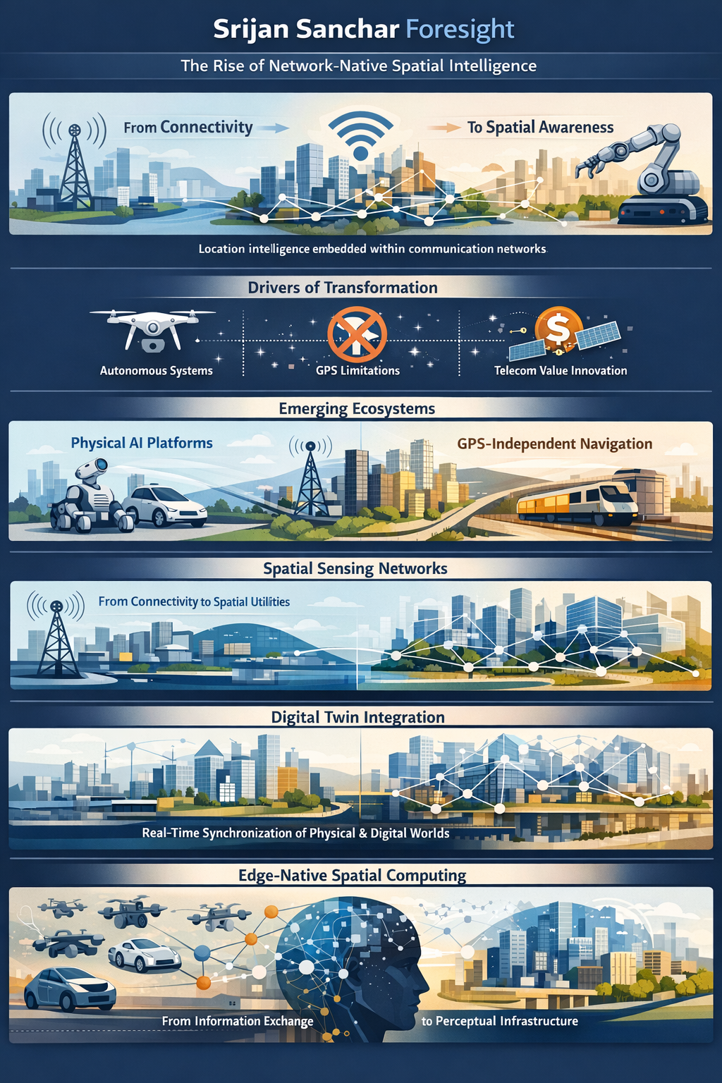
The technological transformation emerging around Zainar Company signals the beginning of a profound infrastructural transition in the relationship between communication networks and physical reality. For decades, communication infrastructure has primarily enabled connectivity—the transfer of voice, data, and digital information across distances. A new evolutionary phase is now unfolding in which the same infrastructure begins to function as a sensing and perception system. Networks are no longer limited to carrying information; they increasingly acquire the ability to understand spatial disposition, movement, and proximity within the physical world.
This transition represents the early formation of what may be described as network-native spatial intelligence. Instead of devices independently determining their location through satellite systems, positioning intelligence shifts into terrestrial communication networks themselves. Wireless infrastructure—5G systems, enterprise networks, and distributed radio environments—gradually transforms into a continuous spatial awareness layer capable of interpreting real-world dynamics in real time. Space becomes computationally observable, shared across systems, and available for machine reasoning.
The emergence of this technological direction is structurally driven rather than speculative. Autonomous systems across logistics, transportation, manufacturing, and defense increasingly require reliable positioning in environments where satellite navigation is inconsistent or unavailable. Dense urban environments, indoor industrial operations, underground systems, and contested electromagnetic conditions expose limitations in existing navigation models. At the same time, telecom operators seek new value architectures capable of leveraging already deployed infrastructure. Converting communication networks into sensing platforms introduces a new economic logic—expanding capability without proportional expansion of physical assets.
Over the next three years, this convergence is expected to catalyze the rise of physical AI ecosystems. Artificial intelligence systems, which currently operate largely within digital environments, begin interacting safely with the physical world through shared spatial awareness generated by communication networks. Robots, autonomous vehicles, inspection systems, and industrial machines gain the ability to coordinate movement collectively rather than operate as isolated intelligent units. Intelligence progressively shifts from device-level autonomy toward network-coordinated cognition.
A parallel evolution is likely in navigation resilience. Network-based positioning systems provide continuity where satellite signals fail, enabling critical infrastructure—railways, ports, airports, mining operations, emergency response systems, and defense applications—to maintain operational awareness under disruption. Navigation thereby transitions from dependence on orbital infrastructure toward ground-based intelligent networks, strengthening systemic resilience in an increasingly uncertain geopolitical and operational environment.
As sensing capability becomes embedded within communication systems, telecom networks themselves evolve into spatial utilities. Beyond connectivity services, networks begin supporting real-time asset visibility, mobility analytics, safety monitoring, infrastructure diagnostics, and coordinated automation. Communication infrastructure gradually assumes characteristics similar to electricity or transportation grids—shared foundational systems supporting multiple economic sectors simultaneously.
This evolution also enables continuous synchronization between physical environments and their digital representations. Cities, industrial facilities, and logistics corridors develop dynamically updated digital twins informed directly through wireless sensing rather than periodic data capture. Planning and management processes shift from episodic decision-making toward continuous optimization, allowing infrastructure systems to respond adaptively to changing conditions.
The technological trajectory points toward increasing decentralization of intelligence through edge-native spatial computing. Positioning and perception computation occurring within distributed network nodes reduces latency and enables cooperative machine behavior at scale. Emerging applications include swarm robotics, coordinated mobility ecosystems, autonomous fleet management, and adaptive urban systems capable of responding collectively to real-time conditions.
Across plausible futures, certain evolutionary characteristics remain stable. Precision timing, interoperability with existing communication standards, and passive compatibility with devices emerge as foundational traits. Deployment models, governance mechanisms, and commercial structures remain fluid as ecosystems mature. Legacy isolated sensing systems gradually lose relevance as shared spatial intelligence embedded within infrastructure becomes economically and operationally superior.
From a foresight perspective, the period between 2026 and 2029 represents an early but decisive transition phase. Initial adoption is expected within enterprise and industrial environments, followed by integration into national infrastructure and large-scale urban systems. By the end of this phase, communication networks may increasingly be understood not merely as channels of information exchange but as perceptual systems enabling real-time understanding of physical environments.
The deeper implication extends beyond technology adoption. The conversion of communication infrastructure into spatial sensing capability introduces a new civilizational layer positioned between connectivity and intelligence. If the Internet connected information and cloud computing enabled large-scale computation, spatially aware networks may enable societies themselves to perceive, coordinate, and evolve with greater adaptive intelligence.
In this emerging landscape, infrastructure begins to sense before it reacts, anticipate before disruption occurs, and coordinate across distributed actors without centralized control. The foresight emerging through Srijan Sanchar therefore indicates that the next stage of technological evolution will not merely digitize systems—it will render the physical world continuously knowable to intelligent networks, fundamentally reshaping how economies, cities, and institutions operate under conditions of growing complexity.